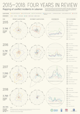
The Geo-located map of conflicts, part of the Conflict Analysis Project, developed by Lebanon Support, in partnership with the United Nations Development Programme (UNDP) tracks incidents, mobilisations and conflicts between individuals/groups/communities happening across Lebanon. This visual provides an overview of the conflicts incidents mapped between 2015 and 2018 focusing on their primary and secondary classifications, locations, and categories.
Image:
Publications page:
New or Old: